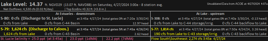
Florida Chlorophyll a and Martin County Chlorophyll a - MODIS (Terra) The "Florida Chlorophyll a" and "Martin County Chlorophyll a" products pull localized imagery from NASA's Global Imagery Browse Services (GIBS) gibs.earthdata.nasa.gov. Eyeonlokeo.com queries two layers from the MODIS sensor on the Terra Satellite, cropping the imagery in separate products for Florida and Martin County. The queries pull the CorrectedReflectance_Bands721 (to show land and clouds), layered with the Chlorophyll_A bands (to show concentrations of chlorophyll in the ocean). Note that a concentration of chlorophyll does not indicate a Harmful Algae Bloom (HAB). These layers are provided to allow users to easily monitor the relationship, if any, between the concentration of chlorophyll off the Florida coasts and discharges from Lake Okeechobee through the St. Lucie and Caloosahatchee Rivers. The "Martin County Chlorophyll a" product goes a step further by querying the South Florida Water Management District's (SFWMD) online DBHydro database (www.sfwmd.gov/science-data/dbhydro). A script pulls the discharge data for the S-80 structure at the St. Lucie canal. S-80 is the spillway located adjacent to the St. Lucie Locks on the C-44 Canal. It is only one of several spillways that empty into the St. Lucie River but it is the terminus of the C-44 canal that carries discharge water from S-308, located at Port Mayaca, together with C-44 basin runoff to S-80 at the St. Lucie Locks. The daily discharge data is added to the bottom of each image. When discharge rates are high at S-80, a large plume of chlorophyll can usually be seen off of the St. Lucie Inlet in Martin County. The plume often moves south close to shore but further from shore the Gulf Stream carries the plume north. Additional layer information from gibs.earthdata.nasa.gov: "The MODIS Chlorophyll a layer provides the near-surface concentration of chlorophyll a in milligrams of chlorophyll pigment per cubic meter (mg/m3) in the ocean. Chlorophyll is a light harvesting pigment found in most photosynthetic organisms. In the ocean, phytoplankton all contain the chlorophyll pigment, which has a greenish color. Derived from the Greek words phyto (plant) and plankton (made to wander or drift), phytoplankton are microscopic organisms that live in watery environments, both salty and fresh. Some phytoplankton are bacteria, some are protists, and most are single-celled plants. The concentration of chlorophyll a is used as an index of phytoplankton biomass. Phytoplankton fix carbon through photosynthesis, taking in dissolved carbon dioxide in the sea water and producing oxygen, enabling phytoplankton to grow. Changes in the amount of phytoplankton indicate the change in productivity of the ocean and as marine phytoplankton capture almost an equal amount of carbon as does photosynthesis by land vegetation, it provides an ocean link to global climate change modeling. The MODIS Chlorophyll a product is therefore a useful product for assessing the health of the ocean. The presence of phytoplankton indicates sufficient nutrient conditions for phytoplankton to flourish, but harmful algal blooms (HABs) can result when high concentrations of phytoplankton produced toxins build up. Known as red tides, blue-green algae or cyanobacteria, harmful algal blooms have severe impacts on human health, aquatic ecosystems and the economy. Chlorophyll features can also be used to trace oceanographic currents, atmospheric jets/streams and upwelling/downwelling/river plumes. Chlorophyll concentration is also useful for studying the earth's climate system as it is plays an integral role in the Global Carbon Cycle. More phytoplankton in the ocean may result in a higher capture rate of carbon dioxide into the ocean and help cool the planet."
Landsat 7,8, Sentinel: Images will be posted here periodically depending on quality, availability and presence of algae. They are posted manually, not with a programming script as is done with the products above. There are two active Landsat satellites (Landsat 7 and Landsat 8), which make nearly direct overhead passes of Lake Okeechobee every 16 days at approximately 11:45 a.m. Their orbits are evenly staggered so that one of the satellites passes every 8 days, taking an image of the entire lake. Seven days after each overhead pass, each Landsat satellite also images the western portion of the lake. Those images usually will not be included here. Landsat 7 has a broken instrument which causes black lines to appear on the imagery. The European Space Agency Sentinel-2 satellites image the lake every few days. Images will include false color SWIR (Short Wave Infrared) images, which make the algae appear brighter than it is to the human eye.
Terra/Aqua/Suomi Last 7 days Dynamic Updates: This page upades automatically each day and dynamically pulls MODIS (Moderate Resolution Imaging Spectroradiometer) and VIIRS (Visible Infrared Imaging Radiometer Suite) images from three satellites. The Terra, Aqua and Suomi satellites take lower resolution imagery of the entire planet each day. Terra typically makes its highest daylight "imagery" pass over Lake Okeechobee from North to South between 11:00 am and 1:00 pm. daily. Aqua and Suomi typically make their highest daylight passes over Lake Okeechobee from South to North between 2:00 pm and 3:30 pm daily. The angle of these satellites in relation to Lake Okeechobee varies greatly each day on the "imagery pass". Thus, the quality of the imagery will vary, as will the amount of haze and sunlight reflection. Because Aqua and Suomi pass later in the afternoon, fewer of those images are included on this page due to afternoon thunderstorms blocking the view of the lake.